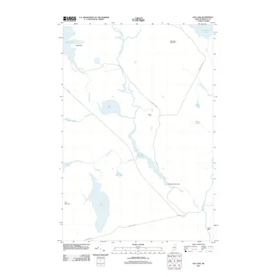
2011 Map of Hay Lake
USGS Topo · Published 2011About this map
Seboeis Farm sits at the heart of this northern Maine landscape, where the Seboeis River and its intricate tributaries dominate the terrain. The hydrological network is highly detailed, showing the complex flow from Scraggy Lake and Snowshoe Lake into various brooks and ponds. Significant features such as the Sawtelle Deadwater Dam and Sawtelle Falls highlight the managed and natural water power of the region. The map also records landmarks like Grand Pitch on the Seboeis River, an area characterized by notable elevations including Snowshoe Mountain, Owls Head, and Hay Mountain. A network of unpaved access routes like Grand Lake Rd and Scraggy Lake Rd provides the primary infrastructure for this remote timber and sporting territory, connecting isolated points of interest across the Penobscot County interior.
Find a feature on this map
28 named features on this map. Tap any name to fly to it.
Don’t see what you’re looking for? This feature index may not catch every label — zoom into the map to look around manually.
Map Details
Editions of this 2011 Hay Lake Map
This is the sole edition of this map. No revisions or reprints were ever made.
Other maps of this area

1954 · Shin Pond
USGS Topo · 1:62,500

1954 · Millinocket Lake
USGS Topo · 1:62,500

1954 · Grand Lake Seboeis
USGS Topo · 1:62,500

1954 · Presque Isle
USGS Topo · 1:250,000

1955 · Traveler Mountain
USGS Topo · 1:62,500

1958 · Presque Isle
USGS Topo · 1:250,000

1960 · Presque Isle
USGS Topo · 1:250,000
1975 · The Traveler
USGS Topo · 1:24,000
1975 · Shin Pond NE
USGS Topo · 1:24,000
1975 · Shin Pond SW
USGS Topo · 1:24,000