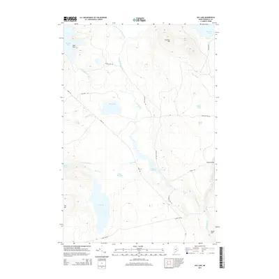
2014 Map of Hay Lake
USGS Topo · Published 2014About this map
Hay Lake and the surrounding wilderness of Penobscot County define this section of Maine’s North Woods, where a complex network of glacial ponds and watercourses serves as the primary landscape features. The drainage system is anchored by the Schoeis River and Sawtelle Brook, which winds through the Sawtelle Deadwater before reaching the dramatic drops of Sawtelle Falls. This 2014 survey documents a territory shaped by timber and recreation, where traditional routes like the Matagamon Tote Rd and Grand Lake Rd provide access to high points such as Snowshoe Mtn and Owls Head. The map's topographic detail captures the transition from the low-lying bogs of Soper Logan to the sharp elevation changes at Grand Pitch and Godfrey Pitch, reflecting the area's value for both watershed conservation and backwoods navigation.
Find a feature on this map
32 named features on this map. Tap any name to fly to it.
Don’t see what you’re looking for? This feature index may not catch every label — zoom into the map to look around manually.
Map Details
Editions of this 2014 Hay Lake Map
This is the sole edition of this map. No revisions or reprints were ever made.
Other maps of this area

1954 · Shin Pond
USGS Topo · 1:62,500

1954 · Millinocket Lake
USGS Topo · 1:62,500

1954 · Grand Lake Seboeis
USGS Topo · 1:62,500

1954 · Presque Isle
USGS Topo · 1:250,000

1955 · Traveler Mountain
USGS Topo · 1:62,500

1958 · Presque Isle
USGS Topo · 1:250,000

1960 · Presque Isle
USGS Topo · 1:250,000
1975 · The Traveler
USGS Topo · 1:24,000
1975 · Shin Pond NE
USGS Topo · 1:24,000
1975 · Shin Pond SW
USGS Topo · 1:24,000