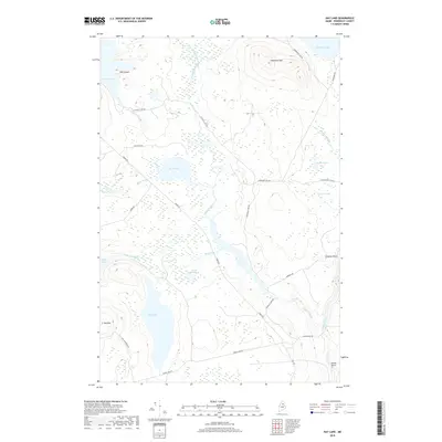
2018 Map of Hay Lake
USGS Topo · Published 2018About this map
Hay Lake and the surrounding wilderness of Penobscot County are defined by a complex network of glacial ponds and logging roads in this 2018 survey. The landscape is punctuated by prominent elevations such as Snowshoe Mtn and Owls Head, with the southern reaches featuring the high ground of Hay Mtn. Water moves through this territory via the Seboeis River and the winding Sawtelle Brook, which drops over Sawtelle Falls before joining the main river channel. The mapping of the Matagamon Tote Rd and Grand Lake Rd highlights the long-standing importance of timber transport in this region. Distinctive river features like Godfrey Pitch and Grand Pitch indicate the presence of rapids or drops along the Seboeis, essential data points for local history enthusiasts tracking the movement of early river drives and the evolution of North Woods transit.
Find a feature on this map
34 named features on this map. Tap any name to fly to it.
Don’t see what you’re looking for? This feature index may not catch every label — zoom into the map to look around manually.
Map Details
Editions of this 2018 Hay Lake Map
This is the sole edition of this map. No revisions or reprints were ever made.
Other maps of this area

1954 · Shin Pond
USGS Topo · 1:62,500

1954 · Millinocket Lake
USGS Topo · 1:62,500

1954 · Grand Lake Seboeis
USGS Topo · 1:62,500

1954 · Presque Isle
USGS Topo · 1:250,000

1955 · Traveler Mountain
USGS Topo · 1:62,500

1958 · Presque Isle
USGS Topo · 1:250,000

1960 · Presque Isle
USGS Topo · 1:250,000
1975 · The Traveler
USGS Topo · 1:24,000
1975 · Shin Pond NE
USGS Topo · 1:24,000
1975 · Shin Pond SW
USGS Topo · 1:24,000