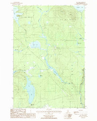
1986 Map of Hay Lake
USGS Topo · Published 1986About this map
Seboeis Farm and the Forest Service Camp represent the few named outposts in this northern Maine landscape during the mid-1980s. The map illustrates a complex network of wetlands and moving water, where Sawtelle Brook and the Upper Seboeis River define the local topography. Notable natural landmarks include the Seboeis River Gorge and the sharp elevation of Snowshoe Mountain in the north. The area is characterized by numerous slow-moving water bodies such as Hobart Deadwater and Sawtelle Deadwater, suggesting a terrain shaped by low gradients and seasonal shifts. Small-scale industrial activity is evidenced by a Sand & Gravel Pit, while recreational points like the Boat Ramp on Hay Lake indicate the region's use for outdoor access within the vast timberlands of Penobscot County.
Find a feature on this map
37 named features on this map. Tap any name to fly to it.
Don’t see what you’re looking for? This feature index may not catch every label — zoom into the map to look around manually.
Map Details
Editions of this 1986 Hay Lake Map
This is the sole edition of this map. No revisions or reprints were ever made.
Other maps of this area

1954 · Shin Pond
USGS Topo · 1:62,500

1954 · Millinocket Lake
USGS Topo · 1:62,500

1954 · Grand Lake Seboeis
USGS Topo · 1:62,500

1954 · Presque Isle
USGS Topo · 1:250,000

1955 · Traveler Mountain
USGS Topo · 1:62,500

1958 · Presque Isle
USGS Topo · 1:250,000

1960 · Presque Isle
USGS Topo · 1:250,000
1975 · The Traveler
USGS Topo · 1:24,000
1975 · Shin Pond NE
USGS Topo · 1:24,000
1975 · Shin Pond SW
USGS Topo · 1:24,000