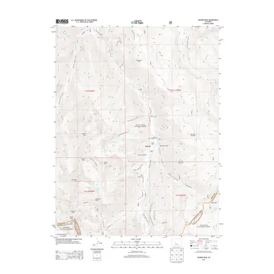
2013 Map of Hayden Peak
USGS Topo · Published 2013About this map
Ashcroft serves as a central point in this high-altitude survey of the Elk Mountains, situated at the confluence of several glacial valleys in the White River National Forest. The settlement pattern reflects the area's transition into a destination for mountaineering and conservation, featuring Toklat Lodge and Elk Mountain Lodge alongside designated campsites like Castle Creek Campground. The topography is dominated by towering summits, including Hayden Peak, Castle Peak, and Cathedral Peak, which hem in remote basins and alpine waters such as American Lake and Cathedral Lake. A complex network of historic routes and high-mountain passes, such as Taylor Pass Rd and Pearl Pass, illustrate the challenging transit across the Pitkin and Gunnison county line, where the landscape falls away into Monument Gulch and the Cumberland Basin.
Find a feature on this map
65 named features on this map. Tap any name to fly to it.
Don’t see what you’re looking for? This feature index may not catch every label — zoom into the map to look around manually.
Map Details
Editions of this 2013 Hayden Peak Map
This is the sole edition of this map. No revisions or reprints were ever made.
Other maps of this area

1888 · Crested Butte
USGS Topo · 1:62,500

1889 · Crested Butte
USGS Topo · 1:62,500

1893 · Crested Butte
USGS Topo · 1:62,500

1893 · Aspen
USGS Topo · 1:62,500

1895 · Aspen
USGS Topo · 1:62,500

1909 · Mount Jackson
USGS Topo · 1:125,000

1911 · Mount Jackson
USGS Topo · 1:125,000

1934 · Taylor Park
USGS Topo · 1:62,500

1937 · Taylor Park
USGS Topo · 1:62,500

1956 · Montrose
USGS Topo · 1:250,000