
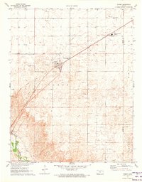
1971 Map of Hayne
USGS Topo · Published 1973About this map
The Chicago Rock Island and Pacific railroad cuts a diagonal path through this High Plains landscape, anchoring the small settlement of Hayne. Situated in southern Kansas just north of the Seward Co Beaver Co line at the Kansas Oklahoma border, the area is defined by its extensive energy infrastructure. The surface is dotted with numerous Gas Wells and Oil Wells, particularly concentrated within the Liberal Gas Field and a broader Oil and Gas Field. A network of Pipelines traverses the terrain to support these operations. Outside of the industrial and transit corridors, the map reveals agricultural and communication landmarks such as a Feeder Lot and a Radio Tower, reflecting the mid-twentieth-century economic reliance on both cattle and carbon.
Find a feature on this map
12 named features on this map. Tap any name to fly to it.
Don’t see what you’re looking for? This feature index may not catch every label — zoom into the map to look around manually.
Map Details
Editions of this 1971 Hayne Map
This is the sole edition of this map. No revisions or reprints were ever made.
Other maps of this area

1954 · Perryton
USGS Topo · 1:250,000

1955 · Dodge City
USGS Topo · 1:250,000

1958 · Perryton
USGS Topo · 1:250,000

1958 · Dodge City
USGS Topo · 1:250,000

1959 · Dodge City
USGS Topo · 1:250,000

1968 · Liberal NE
USGS Topo · 1:24,000

1968 · Liberal NW
USGS Topo · 1:24,000

1971 · Liberal
USGS Topo · 1:24,000
1971 · Kismet
USGS Topo · 1:24,000

1971 · Kismet SW
USGS Topo · 1:24,000