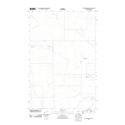
2011 Map of Haynie Reservoir
USGS Topo · Published 2011About this map
Haynie Reservoir and its associated Haynie Reservoir Dam sit at the heart of this McCone County landscape, illustrating the vital role of water management in eastern Montana's ranching economy. The map details a network of ephemeral drainage systems, including the branching reaches of Lost Creek, South Fork Buffalo Creek, and Denwoody Creek. These watercourses are punctuated by numerous smaller engineering projects such as the Nerud Ranch Number 1 Dam, Wahl Stock Reservoir Dam, and Angie Dam, which serve to capture runoff across the arid plains. Remote local transport is facilitated by a grid of rural routes, notably Spring Creek Rd and McKean Rd, which connect isolated ranch holdings and livestock grazing lands in this sparsely populated region of the Big Sky State.
Find a feature on this map
11 named features on this map. Tap any name to fly to it.
Don’t see what you’re looking for? This feature index may not catch every label — zoom into the map to look around manually.
Map Details
Editions of this 2011 Haynie Reservoir Map
This is the sole edition of this map. No revisions or reprints were ever made.
Other maps of this area

1954 · Glendive
USGS Topo · 1:250,000

1957 · Glendive
USGS Topo · 1:250,000

1958 · Glendive
USGS Topo · 1:250,000

1982 · Circle
USGS Topo · 1:100,000

1983 · Youngquist Mine
USGS Topo · 1:24,000

1983 · Brockway NE
USGS Topo · 1:24,000

1983 · Haynie Reservoir
USGS Topo · 1:24,000

1983 · Hudiburgh Reservoir
USGS Topo · 1:24,000

1983 · Pedigo Coulee
USGS Topo · 1:24,000

1983 · North Fork Horse Creek
USGS Topo · 1:24,000