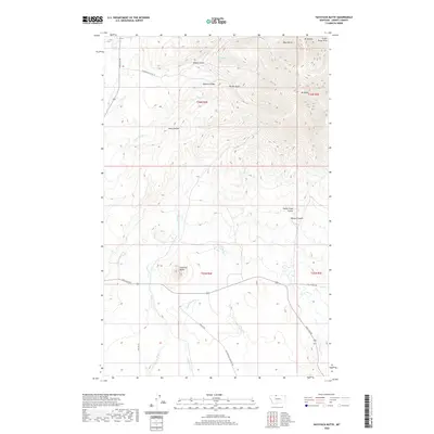
2020 Map of Haystack Butte
USGS Topo · Published 2020About this map
The high peaks of the Sweet Grass Hills dominate this portion of Liberty and Hill Counties, including the prominent heights of Mt Royal and Mt Brown. This landscape is defined by the sharp transition from the plains to these isolated mountains, where deep drainages like Bear Gulch and Ribbon Gulch cut through the rising terrain. Evidence of the region’s ranching and transit history is preserved in the road network, which includes the Old Whitlash Freight Rd and the Thompson Cattle Co lands. Water sources are critical in this arid environment, marked by Big Spring and various seasonal flows such as Strawberry Cr and Little Horse Cr. The presence of Miners Coulee suggests the area's historical prospecting ties, while the solitary Haystack Butte serves as a distinct navigational landmark south of the main peaks.
Find a feature on this map
31 named features on this map. Tap any name to fly to it.
Don’t see what you’re looking for? This feature index may not catch every label — zoom into the map to look around manually.
Map Details
Editions of this 2020 Haystack Butte Map
This is the sole edition of this map. No revisions or reprints were ever made.
Other maps of this area

1954 · Shelby
USGS Topo · 1:250,000

1958 · Shelby
USGS Topo · 1:250,000
1962 · Bingham Lake
USGS Topo · 1:24,000

1962 · Lakey Ranch
USGS Topo · 1:24,000

1962 · Whitlash
USGS Topo · 1:24,000

1962 · Berkholder Reservoir
USGS Topo · 1:24,000

1962 · Blair Ranch
USGS Topo · 1:24,000
1962 · Hawley Hill
USGS Topo · 1:24,000

1962 · Haystack Butte
USGS Topo · 1:24,000

1962 · Mount Lebanon
USGS Topo · 1:24,000