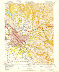
1950 Map of Hayward
USGS Topo · Published 1950About this map
Hayward and the surrounding East Bay communities are shown here following World War II, a period of rapid suburbanization. The map documents the residential expansion into the Seven Hills and the development of San Lorenzo Village adjacent to the Southern Pacific and Western Pacific rail lines. To the north, the waters of Lake Chabot are bordered by the Lake Chabot Golf Course, while the eastern landscape remains dominated by the steep terrain of Walpert Ridge and deep canyons like Cull Creek and Palomares Creek. Institutional landmarks of the era are prominent, including the Fairmont Hospital and the Alameda County Jail. The infrastructure of the growing city is further detailed by numerous schools such as Hayward Union High Sch and Bret Harte Sch, alongside the sprawling grounds of the Hayward Municipal Airport and the now-lost Oakland Speedway.
Find a feature on this map
74 named features on this map. Tap any name to fly to it.
Don’t see what you’re looking for? This feature index may not catch every label — zoom into the map to look around manually.
Map Details
Editions of this 1950 Hayward Map
This is the sole edition of this map. No revisions or reprints were ever made.
Other maps of this area

1896 · Mt. Diablo
USGS Topo · 1:62,500

1897 · Concord
USGS Topo · 1:62,500

1898 · Mt. Diablo
USGS Topo · 1:62,500

1899 · Haywards
USGS Topo · 1:62,500

1906 · Pleasanton
USGS Topo · 1:62,500

1915 · Haywards
USGS Topo · 1:62,500

1915 · Concord
USGS Topo · 1:62,500

1941 · Pleasanton
USGS Topo · 1:62,500

1942 · Concord
USGS Topo · 1:62,500

1942 · Hayward
USGS Topo · 1:62,500