1993 Map of Hayward
USGS Topo · Published 1997About this map
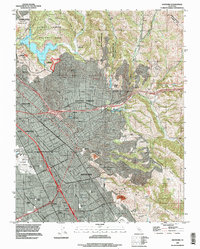
Hayward and the surrounding East Bay communities are shown here at a moment of significant late-20th-century density, anchored by the industrial and transport corridor of the Nimitz Freeway. The map illustrates the complex social infrastructure of the era, from educational centers like California State University Hayward and Chabot College to a high concentration of institutional landmarks including Fairmont Hospital, Kaiser Hospital, and St Rose Hospital.
Find a feature on this map
53 named features on this map. Tap any name to fly to it.
Don’t see what you’re looking for? This feature index may not catch every label — zoom into the map to look around manually.
Map Details
Editions of this 1993 Hayward Map
This is the sole edition of this map. No revisions or reprints were ever made.
Other maps of this area

1896 · Mt. Diablo
USGS Topo · 1:62,500

1897 · Concord
USGS Topo · 1:62,500

1898 · Mt. Diablo
USGS Topo · 1:62,500

1899 · Haywards
USGS Topo · 1:62,500

1906 · Pleasanton
USGS Topo · 1:62,500

1915 · Haywards
USGS Topo · 1:62,500

1915 · Concord
USGS Topo · 1:62,500

1941 · Pleasanton
USGS Topo · 1:62,500

1942 · Concord
USGS Topo · 1:62,500

1942 · Hayward
USGS Topo · 1:62,500