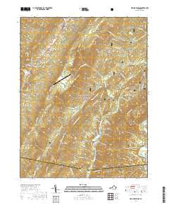
2019 Map of Healing Springs
USGS Topo · Published 2019About this map
Healing Springs and the surrounding high-altitude ridges of the George Washington National Forest characterize this portion of the Alleghany Mountains. The map documents the high-elevation airfield at Ingalls Field, situated atop a flat-topped ridge known as Big Ridge, serving as a striking human imprint on this steep terrain. Along the northwestern edge, small communities like Ashwood, Midway, and Tinkertown sit within the narrow corridors of the Warm Springs Valley.
Find a feature on this map
92 named features on this map. Tap any name to fly to it.
Don’t see what you’re looking for? This feature index may not catch every label — zoom into the map to look around manually.
Map Details
Editions of this 2019 Healing Springs Map
This is the sole edition of this map. No revisions or reprints were ever made.
Other maps of this area

1894 · Natural Bridge
USGS Topo · 1:125,000

1901 · Monterey
USGS Topo · 1:125,000

1923 · Warm Springs
USGS Topo · 1:48,000

1926 · Warm Springs
USGS Topo · 1:62,500

1929 · Falling Spring
USGS Topo · 1:24,000

1930 · Warm Springs Run
USGS Topo · 1:24,000

1930 · Mountain Grove
USGS Topo · 1:24,000

1931 · Healing Springs
USGS Topo · 1:24,000

1932 · Falling Spring
USGS Topo · 1:31,680

1933 · Mountain Grove
USGS Topo · 1:31,680