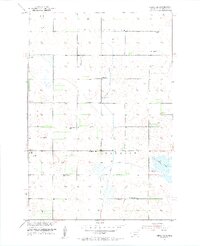
1953 Map of Hecla SE
USGS Topo · Published 1955About this map
Renzienhausen Slough anchors the southeastern landscape of this rural Brown County territory, which was surveyed at a time when small rural schoolhouses still stood as centers of community life. The quadrangle is divided into the civil townships of Portage, Lansing, Detroit, and Shelby, revealing a grid of section lines dotted with localized infrastructure. While Dinger Sch was already noted as abandoned by the early 1950s, the Heinemann Sch and Rasmussen Sch remained as landmarks alongside the Town Hall. Numerous Flowing Wells are mapped across the prairie, indicating the importance of groundwater for the region's agricultural viability. The topography is also shaped by drainage and reclamation efforts, marked by a prominent Spoil Bank running along the western edge of the township lines.
Find a feature on this map
12 named features on this map. Tap any name to fly to it.
Don’t see what you’re looking for? This feature index may not catch every label — zoom into the map to look around manually.
Map Details
Editions of this 1953 Hecla SE Map
2 editions found
Other maps of this area

1894 · Hecla
USGS Topo · 1:62,500

1896 · Columbia
USGS Topo · 1:125,000

1953 · Hecla SE
USGS Topo · 1:24,000

1953 · Houghton
USGS Topo · 1:24,000

1953 · Newark SW
USGS Topo · 1:24,000

1953 · Milbank
USGS Topo · 1:250,000

1954 · Daly Corners
USGS Topo · 1:24,000

1954 · Aberdeen
USGS Topo · 1:250,000

1956 · Aberdeen
USGS Topo · 1:250,000
1956 · Hecla
USGS Topo · 1:24,000
Featured Places
- Shelby Township, SD
- Hecla Township, SD
- Lansing Township, SD
- Portage Township, SD
- North Detroit Township, SD