1988 Map of Hedges
USGS Topo · Published 1988About this map
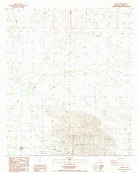
The Cargo Muchacho Mountains dominate the southern landscape of this California desert region, where a history of extraction is marked by the presence of the Tumco Mine and various Prospects. The map identifies the specific location of Hedges (Site), a former mining settlement alongside Tumco, offering a clear view of the area's industrial footprint in the late 20th century. Near the foot of the range, a Cem and Gold Rock Ranch Trailer Park represent the sparse human presence amidst the arid terrain. The drainage patterns of Indian Wash and other unnamed seasonal washes provide the primary geographical structure to the north, cutting through the high desert floor between the mountains and the various mining pits and survey benchmarks that define this rugged corner of Imperial County.
Find a feature on this map
15 named features on this map. Tap any name to fly to it.
Don’t see what you’re looking for? This feature index may not catch every label — zoom into the map to look around manually.
Map Details
Editions of this 1988 Hedges Map
This is the sole edition of this map. No revisions or reprints were ever made.
Other maps of this area

1903 · Yuma
USGS Topo · 1:125,000

1905 · Yuma
USGS Topo · 1:125,000

1942 · Yuma
USGS Topo · 1:250,000

1942 · Blythe
USGS Topo · 1:250,000

1945 · Picacho Peak
USGS Topo · 1:62,500

1945 · Picacho
USGS Topo · 1:62,500

1951 · Picacho
USGS Topo · 1:62,500

1951 · Picacho Peak
USGS Topo · 1:62,500

1952 · Araz
USGS Topo · 1:24,000

1953 · Quartz Peak
USGS Topo · 1:62,500