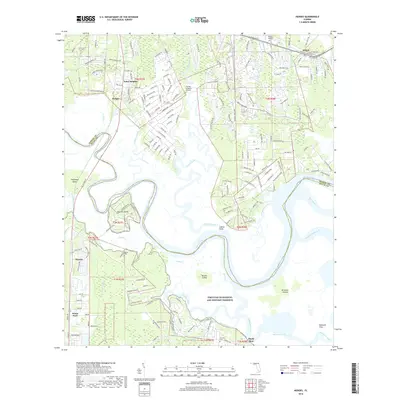
2018 Map of Hedges
USGS Topo · Published 2018About this map
The Nassau River dominates this coastal landscape where the waters of Lofton Creek and Pumpkin Hill Creek converge amid a complex network of islands and marshes. This 2018 survey illustrates the suburban expansion of northern Jacksonville and southern Nassau County, centered on settlements like Yulee Heights, Hedges, and O'Neil. Large portions of the terrain are protected within the Timucuan Ecological and Historic Preserve, securing the ecological integrity of the Broward Islands and Burton Island. Local aviation is represented by the Nassau Airport and the more localized Flying-A-Ranch Airport. Genealogists may find value in the location of the Bowles Cem near the riverbanks and the Ferreira Cem further south, providing evidence of family settlements along the various creeks like Starrett Creek and Mink Cr.
Find a feature on this map
183 named features on this map. Tap any name to fly to it.
Don’t see what you’re looking for? This feature index may not catch every label — zoom into the map to look around manually.
Map Details
Editions of this 2018 Hedges Map
This is the sole edition of this map. No revisions or reprints were ever made.
Other maps of this area

1918 · St Marys
USGS Topo · 1:62,500

1918 · Jacksonville
USGS Topo · 1:62,500

1918 · Mayport
USGS Topo · 1:62,500

1919 · Fernandina
USGS Topo · 1:62,500

1919 · St Marys
USGS Topo · 1:62,500

1944 · Fernandina
USGS Topo · 1:62,500

1948 · Jacksonville
USGS Topo · 1:250,000

1948 · Eastport
USGS Topo · 1:24,000
1950 · Mayport
USGS Topo · 1:24,000

1950 · Trout River
USGS Topo · 1:24,000