
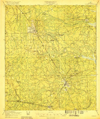
1950 Map of Trout River
USGS Topo · Published 1950About this map
The Trout River and Ribault River converge in this mid-century landscape, carving through a region defined by established cemeteries, early aviation, and expanding neighborhoods north of Jacksonville. To the south, numerous burial grounds such as Restlawn Memorial Park, Greenwood Cem, and Pinehurst Cem are clustered near the banks, reflecting the area's long-standing role as a community landmark. The industrial and civic growth of the era is evidenced by the Jacksonville Municipal Airport and the nearby City Prison Farm.
Find a feature on this map
51 named features on this map. Tap any name to fly to it.
Don’t see what you’re looking for? This feature index may not catch every label — zoom into the map to look around manually.
Map Details
Editions of this 1950 Trout River Map
This is the sole edition of this map. No revisions or reprints were ever made.
Other maps of this area

1917 · Cambon
USGS Topo · 1:62,500

1917 · Hilliard
USGS Topo · 1:62,500

1918 · St Marys
USGS Topo · 1:62,500

1918 · Cambon
USGS Topo · 1:62,500

1918 · Jacksonville
USGS Topo · 1:62,500

1919 · St Marys
USGS Topo · 1:62,500
1919 · Hilliard
USGS Topo · 1:62,500

1948 · Jacksonville
USGS Topo · 1:250,000

1948 · Eastport
USGS Topo · 1:24,000
1950 · Arlington
USGS Topo · 1:24,000
Featured Places
- Jacksonville, FL
- Lake Park Estates, Jacksonville
- Lake Forest Manor, Jacksonville
- Garden City, Jacksonville
- Oakhurst, Jacksonville