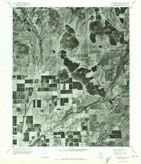
1971 Map of Hedgpeth Hills
USGS Topo · Published 1972About this map
Hedgpeth Hills dominate the central-eastern portion of this 1971 orthophotoquad, which uses aerial photography to document the Maricopa County landscape at a moment of transition. While the northern reaches of the quadrangle remain largely undeveloped desert terrain, the southern sections display a distinct shift toward intensive agriculture. A rigid grid of irrigation and field patterns defines the land use around Skunk Creek, while the New River meanders across the western edge of the sheet. The contrast between the natural topography of Pyramid Pk and the emerging industrial-scale farming provides a clear look at how water management was reshaping the Phoenix-area periphery in the early 1970s.
Find a feature on this map
4 named features on this map. Tap any name to fly to it.
Don’t see what you’re looking for? This feature index may not catch every label — zoom into the map to look around manually.
Map Details
Editions of this 1971 Hedgpeth Hills Map
This is the sole edition of this map. No revisions or reprints were ever made.
Other maps of this area

1954 · Phoenix
USGS Topo · 1:250,000

1957 · Phoenix
USGS Topo · 1:250,000

1957 · Calderwood Butte
USGS Topo · 1:24,000

1957 · El Mirage
USGS Topo · 1:24,000

1957 · Hedgpeth Hills
USGS Topo · 1:24,000

1957 · Glendale
USGS Topo · 1:24,000

1958 · Phoenix
USGS Topo · 1:250,000

1960 · Phoenix
USGS Topo · 1:250,000
1964 · Baldy Mtn
USGS Topo · 1:24,000
1964 · New River SE
USGS Topo · 1:24,000