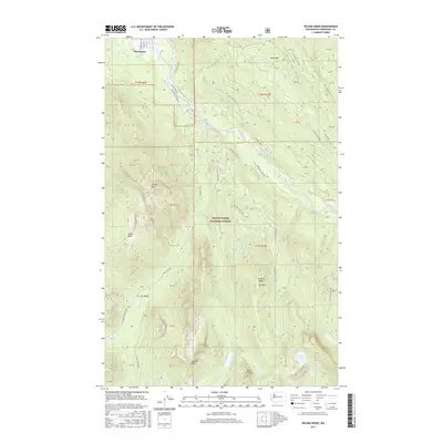
2017 Map of Helena Ridge
USGS Topo · Published 2017About this map
Darrington anchors the northwestern corner of this study, serving as a gateway to the high elevations of the Mount Baker National Forest. The landscape is dominated by the massive relief of Jumbo Mtn and Helena Ridge, where drainages like Asbestos Cr and Frog Creek descend through steep canyons. Significant water features including Kirk Lake, Lake Angeline, and North Lake are nestled among summits like Iron Mtn and Gold Mtn.
Find a feature on this map
60 named features on this map. Tap any name to fly to it.
Don’t see what you’re looking for? This feature index may not catch every label — zoom into the map to look around manually.
Map Details
Editions of this 2017 Helena Ridge Map
This is the sole edition of this map. No revisions or reprints were ever made.
Other maps of this area
1899 · Glacier Peak
USGS Topo · 1:125,000
1899 · Stillaguamish
USGS Topo · 1:125,000
1901 · Glacier Peak
USGS Topo · 1:125,000
1901 · Stilaguamish
USGS Topo · 1:125,000

1955 · Concrete
USGS Topo · 1:250,000
1957 · Silverton
USGS Topo · 1:62,500

1958 · Concrete
USGS Topo · 1:250,000

1962 · Concrete
USGS Topo · 1:250,000
1966 · Darrington
USGS Topo · 1:24,000
1966 · Bedal
USGS Topo · 1:24,000