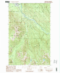
1989 Map of Helena Ridge
USGS Topo · Published 1989About this map
Darrington serves as the northern gateway to this 1989 provisional study of Snohomish County, where the valley floor quickly gives way to the protected heights of the Mt Baker National Forest. The landscape is dominated by the Sauk River (Wild and Scenic River), which carves a path between the Boulder River Wilderness and high-altitude water bodies like Lake Angeline. The presence of Asbestos Cr and Asbestos Falls points to the area's mineral prospects, while prominent landmarks such as Jumbo Mountain and Iron Mountain define the vertical relief of Helena Ridge. The map details the transition from the settled valley near Kirk Lake to the remote backcountry of Windom Lake and North Lake, offering researchers a clear look at the trail and river systems before modern alterations changed the accessibility of these peaks.
Find a feature on this map
41 named features on this map. Tap any name to fly to it.
Don’t see what you’re looking for? This feature index may not catch every label — zoom into the map to look around manually.
Map Details
Editions of this 1989 Helena Ridge Map
This is the sole edition of this map. No revisions or reprints were ever made.
Other maps of this area

1899 · Glacier Peak
USGS Topo · 1:125,000

1899 · Stillaguamish
USGS Topo · 1:125,000

1901 · Glacier Peak
USGS Topo · 1:125,000

1901 · Stilaguamish
USGS Topo · 1:125,000

1955 · Concrete
USGS Topo · 1:250,000

1957 · Silverton
USGS Topo · 1:62,500

1958 · Concrete
USGS Topo · 1:250,000

1962 · Concrete
USGS Topo · 1:250,000
1966 · Darrington
USGS Topo · 1:24,000
1966 · Bedal
USGS Topo · 1:24,000