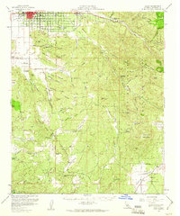
1957 Map of Hemet
USGS Topo · Published 1960About this map
The San Jacinto Valley anchors the northwest corner of this mid-century survey, showing the organized grid of Hemet and Valle Vista before decades of modern expansion. The landscape transitions quickly from these agricultural and residential centers into the high, broken terrain of the Santa Rosa Hills and the San Bernardino National Forest. The presence of the Atchison Topeka and Santa Fe railroad line underscores the area's importance as a regional hub for the shipment of valley produce.
Find a feature on this map
43 named features on this map. Tap any name to fly to it.
Don’t see what you’re looking for? This feature index may not catch every label — zoom into the map to look around manually.
Map Details
Editions of this 1957 Hemet Map
3 editions found
Other maps of this area

1901 · Southern California Sheet No. 1
USGS Topo · 1:250,000

1901 · San Jacinto
USGS Topo · 1:125,000

1901 · Elsinore
USGS Topo · 1:125,000

1901 · San Luis Rey
USGS Topo · 1:125,000

1903 · Ramona
USGS Topo · 1:125,000

1904 · Southern California Sheet No. 2
USGS Topo · 1:250,000

1904 · Southern California Sheet No. 1
USGS Topo · 1:250,000

1939 · Warner Springs
USGS Topo · 1:62,500

1939 · Palomar Mountain
USGS Topo · 1:62,500

1940 · Palm Springs
USGS Topo · 1:62,500