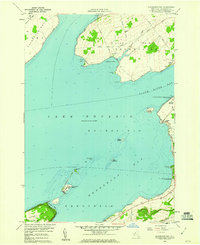
1959 Map of Henderson Bay
USGS Topo · Published 1960About this map
Lake Ontario dominates this 1959 coastal survey, framing the irregular shoreline of Jefferson County where protected waters meet the open lake. The maritime heritage of the region is centered on Sackets Harbor, featuring the Sackets Harbor Battlefield State Park and navigation aids like the Light Tower Horse Island. The map details a complex geography of peninsulas and islands, including Lyme Point Peninsula and the offshore Association Island, which are critical to the character of Henderson Bay.
Find a feature on this map
36 named features on this map. Tap any name to fly to it.
Don’t see what you’re looking for? This feature index may not catch every label — zoom into the map to look around manually.
Map Details
Editions of this 1959 Henderson Bay Map
This is the sole edition of this map. No revisions or reprints were ever made.
Other maps of this area

1893 · Sackets Harbor
USGS Topo · 1:62,500

1895 · Sacketts Harbor
USGS Topo · 1:62,500

1895 · Stony Island
USGS Topo · 1:62,500

1895 · Cape Vincent
USGS Topo · 1:62,500

1900 · Clayton
USGS Topo · 1:62,500

1903 · Clayton
USGS Topo · 1:62,500

1942 · Stony Point
USGS Topo · 1:31,680

1942 · Henderson Bay
USGS Topo · 1:31,680

1942 · Chaumont
USGS Topo · 1:31,680

1942 · Cape Vincent South
USGS Topo · 1:31,680