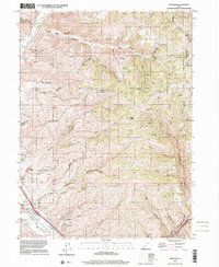
1997 Map of Henefer
USGS Topo · Published 2001About this map
Henefer sits along the southern bank of the Weber River in the Henefer Valley, serving as a focal point for this landscape near the turn of the 21st century. The map documents a terrain deeply shaped by water and elevation, from the heights of Windy Knoll and Middle Ridge to the convergence of Lost Creek and Echo Creek. A notable presence of industrial and commemorative sites appears here, including a Pumping Station, several Claypits, and a Borrow Pit near the river, signaling the local extraction and utility infrastructure. Genealogists and local historians can locate the Pioneer Monument and traces of the settlement at China Town in the northern canyon reaches. The area is also defined by its complex drainage network, with numerous family-named or descriptive canyons like Anderton Canyon, Rocky Canyon, and Wolf Den Canyon carving through the borders of Morgan and Summit counties.
Find a feature on this map
39 named features on this map. Tap any name to fly to it.
Don’t see what you’re looking for? This feature index may not catch every label — zoom into the map to look around manually.
Map Details
Editions of this 1997 Henefer Map
This is the sole edition of this map. No revisions or reprints were ever made.
Other maps of this area

1885 · Salt Lake
USGS Topo · 1:250,000

1900 · Coalville
USGS Topo · 1:125,000

1903 · Coalville
USGS Topo · 1:125,000

1925 · Ft. Douglas
USGS Topo · 1:125,000

1928 · Ft. Douglas
USGS Topo · 1:125,000

1954 · Salt Lake City
USGS Topo · 1:250,000

1954 · Ogden
USGS Topo · 1:250,000

1958 · Ogden
USGS Topo · 1:250,000

1958 · Salt Lake City
USGS Topo · 1:250,000

1960 · Ogden
USGS Topo · 1:250,000