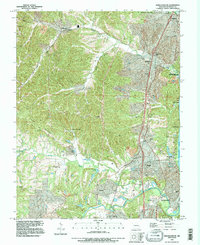
1993 Map of Herculaneum
USGS Topo · Published 1995About this map
Herculaneum and its neighboring riverfront towns are depicted during a period of significant suburban development along the Mississippi River. While industrial and transport corridors like the Burlington Northern railroad and Interchange 186 facilitate modern transit, the map preserves the deeper history of Jefferson County through numerous family and church burial grounds. Notable sites such as Mahlers Cem, Harrington Cem, and Emmanuel Cem are scattered across the landscape, providing essential touchpoints for genealogical research.
Find a feature on this map
43 named features on this map. Tap any name to fly to it.
Don’t see what you’re looking for? This feature index may not catch every label — zoom into the map to look around manually.
Map Details
Editions of this 1993 Herculaneum Map
This is the sole edition of this map. No revisions or reprints were ever made.
Other maps of this area

1901 · De Soto
USGS Topo · 1:125,000

1912 · Kimmswick
USGS Topo · 1:62,500

1915 · Crystal City
USGS Topo · 1:62,500

1916 · Kimmswick
USGS Topo · 1:62,500

1930 · De Soto NE
USGS Topo · 1:24,000

1930 · Pacific SE
USGS Topo · 1:24,000

1931 · Pacific NE
USGS Topo · 1:24,000

1948 · Kimmswick
USGS Topo · 1:62,500

1949 · Saint Louis
USGS Topo · 1:250,000

1949 · Crystal City
USGS Topo · 1:62,500