1948 Map of Kimmswick
USGS Topo · Published 1955About this map
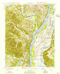
Jefferson Barracks anchors the northern reaches of this Mississippi River corridor, a landscape defined by the confluence of heavy rail traffic and waterborne commerce just south of St. Louis. The Mississippi River serves as a massive boundary between the bluffs of Rock and Joachim townships in Missouri and the low-lying bottoms of Moredock and Bluff in Illinois. Industrial and transit hubs such as Herculaneum and Kimmswick are linked by the Missouri Pacific and the St Louis Iron Mountain and Southern railroads, which hug the riverbanks and facilitate the movement of goods from the interior.
Find a feature on this map
90 named features on this map. Tap any name to fly to it.
Don’t see what you’re looking for? This feature index may not catch every label — zoom into the map to look around manually.
Map Details
Editions of this 1948 Kimmswick Map
This is the sole edition of this map. No revisions or reprints were ever made.
Other maps of this area

1888 · St. Louis
USGS Topo · 1:62,500

1901 · De Soto
USGS Topo · 1:125,000

1903 · O'Fallon
USGS Topo · 1:125,000

1910 · Waterloo
USGS Topo · 1:62,500

1912 · Kimmswick
USGS Topo · 1:62,500

1913 · Waterloo
USGS Topo · 1:62,500

1915 · Renault
USGS Topo · 1:62,500

1915 · Crystal City
USGS Topo · 1:62,500

1916 · Kimmswick
USGS Topo · 1:62,500

1930 · De Soto NE
USGS Topo · 1:24,000