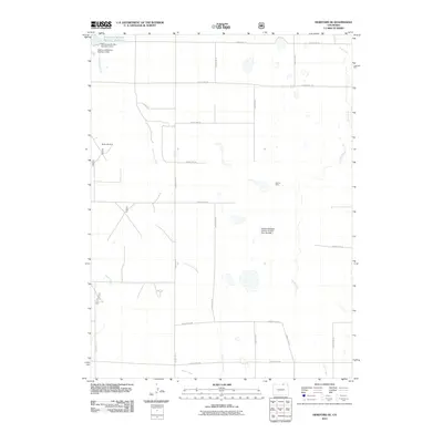
2011 Map of Hereford SE
USGS Topo · Published 2011About this map
Adams and Bunker Reservoir Number 3 and its associated infrastructure define the northwest corner of this Colorado high plains landscape. The area is characterized by a network of drainage systems including Little Crow Creek, Geary Creek, and Crow Creek, which reflect the critical importance of water management in this arid region. Traces of human activity and resource extraction are scattered throughout the quadrangle, notably at the Grover Mine and the McKay Windmill. The land is meticulously subdivided by a grid of county roads, such as County Rd-79 and County Rd-108, indicating a highly organized agricultural or ranching geography. Engineering for land conservation is evident at the Edward Madigan Erosion Control Dam Number 1, highlighting localized efforts to manage the sparse but vital water flow through the northern Colorado landscape.
Find a feature on this map
24 named features on this map. Tap any name to fly to it.
Don’t see what you’re looking for? This feature index may not catch every label — zoom into the map to look around manually.
Map Details
Editions of this 2011 Hereford SE Map
This is the sole edition of this map. No revisions or reprints were ever made.
Other maps of this area

1954 · Greeley
USGS Topo · 1:250,000

1957 · Greeley
USGS Topo · 1:250,000

1958 · Greeley
USGS Topo · 1:250,000

1961 · Greeley
USGS Topo · 1:250,000

1964 · Greeley
USGS Topo · 1:250,000

1965 · Greeley
USGS Topo · 1:250,000
1972 · Grover North
USGS Topo · 1:24,000

1972 · Briggsdale
USGS Topo · 1:24,000

1972 · Keota NW
USGS Topo · 1:24,000
1972 · Reno Reservoir
USGS Topo · 1:24,000