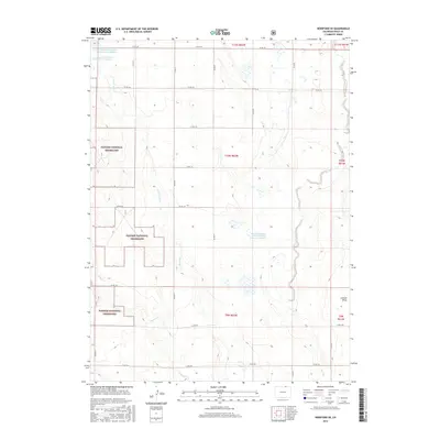
2016 Map of Hereford SE
USGS Topo · Published 2016About this map
The Pawnee National Grassland dominates this section of Weld County, Colorado, characterized by a structured grid of county roads that carve through the high plains. The landscape is defined by its intermittent water management systems, including the Adams and Bunker Reservoir Number 2 and Adams and Bunker Reservoir Number 3 in the northwestern corner. These features, along with the Edward Madigan Erosion Control Reservoir Number 1, reflect the region's historical and ongoing efforts to manage water in a semi-arid environment. Narrow drainages like Little Crow Cr and Geary Cr cross the townships, while Jackson Draw cuts through the eastern edge. This map provides a clear view of the public lands and rural infrastructure as they existed in the mid-2010s, illustrating the intersection of federal land management and local agricultural access.
Find a feature on this map
29 named features on this map. Tap any name to fly to it.
Don’t see what you’re looking for? This feature index may not catch every label — zoom into the map to look around manually.
Map Details
Editions of this 2016 Hereford SE Map
This is the sole edition of this map. No revisions or reprints were ever made.
Other maps of this area

1954 · Greeley
USGS Topo · 1:250,000

1957 · Greeley
USGS Topo · 1:250,000

1958 · Greeley
USGS Topo · 1:250,000

1961 · Greeley
USGS Topo · 1:250,000

1964 · Greeley
USGS Topo · 1:250,000

1965 · Greeley
USGS Topo · 1:250,000
1972 · Grover North
USGS Topo · 1:24,000

1972 · Briggsdale
USGS Topo · 1:24,000

1972 · Keota NW
USGS Topo · 1:24,000
1972 · Reno Reservoir
USGS Topo · 1:24,000