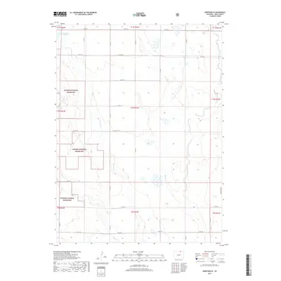
2019 Map of Hereford SE
USGS Topo · Published 2019About this map
Pawnee National Grassland dominates this corner of Weld County, characterized by a complex network of seasonal drainage channels and arid terrain. Water management is central to this landscape, as seen with the Adams and Bunker Reservoir Number 2 in the northwestern quadrant, which captures flow from Little Crow Creek. The map details a strictly organized grid of county roads, including Co RD 122 and Co RD 106, which provide access through the open shortgrass prairie. The topography is defined by subtle elevation changes and natural depressions like Jackson Draw and the winding course of Crow Creek in the east. This 2019 survey documents a landscape where agricultural infrastructure and public lands intersect within the traditional Public Land Survey System township and range boundaries.
Find a feature on this map
30 named features on this map. Tap any name to fly to it.
Don’t see what you’re looking for? This feature index may not catch every label — zoom into the map to look around manually.
Map Details
Editions of this 2019 Hereford SE Map
This is the sole edition of this map. No revisions or reprints were ever made.
Other maps of this area

1954 · Greeley
USGS Topo · 1:250,000

1957 · Greeley
USGS Topo · 1:250,000

1958 · Greeley
USGS Topo · 1:250,000

1961 · Greeley
USGS Topo · 1:250,000

1964 · Greeley
USGS Topo · 1:250,000

1965 · Greeley
USGS Topo · 1:250,000
1972 · Grover North
USGS Topo · 1:24,000

1972 · Briggsdale
USGS Topo · 1:24,000

1972 · Keota NW
USGS Topo · 1:24,000
1972 · Reno Reservoir
USGS Topo · 1:24,000