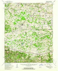
1957 Map of Herndon
USGS Topo · Published 1964About this map
Fort Campbell Military Reservation dominates the central landscape of this mid-century survey, illustrating the extensive military footprint across the Kentucky and Tennessee border. The map captures a significant transitional moment for the region as Lake Barkley (Dam Under Construction) begins to alter the hydrology of the Cumberland River basin. Scattered rural settlements like Lafayette and Indian Mound are surrounded by a network of family-named burial grounds and local institutions, including the Odd Fellows Cem, Double Barn Cem, and South Christian Sch. Numerous watercourses such as Little River and Elk Fork carve through the terrain, while landmarks like the Lookout Tower near Lafayette and the Landing Field indicate the varied uses of the land during this era of military expansion and federal water management projects.
Find a feature on this map
55 named features on this map. Tap any name to fly to it.
Don’t see what you’re looking for? This feature index may not catch every label — zoom into the map to look around manually.
Map Details
Editions of this 1957 Herndon Map
This is the sole edition of this map. No revisions or reprints were ever made.
Other maps of this area

1931 · Erin
USGS Topo · 1:62,500

1936 · Dover
USGS Topo · 1:24,000

1944 · Clarksville
USGS Topo · 1:50,000

1950 · Dover
USGS Topo · 1:24,000

1950 · Caledonia
USGS Topo · 1:24,000

1951 · Church Hill
USGS Topo · 1:24,000

1951 · Caledonia
USGS Topo · 1:24,000

1951 · Hopkinsville
USGS Topo · 1:24,000

1951 · Roaring Spring
USGS Topo · 1:24,000

1951 · New Providence
USGS Topo · 1:24,000