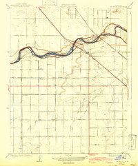
1923 Map of Herndon
USGS Topo · Published 1942About this map
The San Joaquin River defines the border between Fresno and Madera counties, weaving through a landscape transition from river bluffs to the precisely gridded agricultural plains of the Central Valley. In the 1920s, the small settlement of Herndon served as a vital crossing point, where the State Highway and the Southern Pacific railroad shared a corridor over the water. This survey illustrates the early 20th-century development of the region, featuring a secondary rail line by the Atchison Topeka and Santa Fe and established local centers like Barstow and Dickerson. The southern half of the map is dominated by a systematic road network, including Shields Avenue, Ashlan Avenue, and Shaw Avenue, which supported the expanding irrigation and farming operations that would eventually become the suburbs of Fresno.
Find a feature on this map
16 named features on this map. Tap any name to fly to it.
Don’t see what you’re looking for? This feature index may not catch every label — zoom into the map to look around manually.
Map Details
Editions of this 1923 Herndon Map
2 editions found
Other maps of this area

1921 · Bullard
USGS Topo · 1:31,680

1922 · Lanes Bridge
USGS Topo · 1:31,680

1922 · Gregg
USGS Topo · 1:31,680

1922 · Madera
USGS Topo · 1:31,680

1923 · Kearney Park
USGS Topo · 1:31,680

1923 · Herndon
USGS Topo · 1:31,680

1923 · Fresno
USGS Topo · 1:31,680

1923 · Biola
USGS Topo · 1:31,680

1923 · Bullard
USGS Topo · 1:31,680
1946 · Fresno South
USGS Topo · 1:24,000