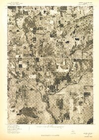
1976 Map of Hersperia SW
USGS Topo · Published 1976About this map
The settlement of Ferry sits as the primary human focal point in this 1976 orthophotoquad, which uses aerial imagery to document the rural landscape of Oceana County. Unlike a traditional topographic map, this photographic survey reveals the precise textures of Michigan’s agricultural and forested terrain, showing the intricate patchwork of cultivated fields and woodlots. The meandering river valley and numerous small lakes and wetlands across the quadrangle highlight the area's complex glacial geography. Researchers can observe the interplay between developed farmstead clearings and the dense vegetation that borders the winding waterways, providing a clear visual record of mid-1970s land use patterns in this part of western Michigan.
Find a feature on this map
1 named feature on this map. Tap any name to fly to it.
Don’t see what you’re looking for? This feature index may not catch every label — zoom into the map to look around manually.
Map Details
Editions of this 1976 Hersperia SW Map
This is the sole edition of this map. No revisions or reprints were ever made.
Other maps of this area

1929 · Montague
USGS Topo · 1:48,000

1931 · Hart SE
USGS Topo · 1:31,680

1931 · Walkerville NE
USGS Topo · 1:31,680

1931 · Hart NE
USGS Topo · 1:31,680

1931 · Walkerville SW
USGS Topo · 1:31,680

1931 · Walkerville NW
USGS Topo · 1:31,680

1931 · Walkerville SE
USGS Topo · 1:31,680

1954 · Milwaukee
USGS Topo · 1:250,000

1958 · Milwaukee
USGS Topo · 1:250,000

1958 · Hesperia
USGS Topo · 1:62,500