1942 Map of Hesperia
USGS Topo · Published 1942About this map
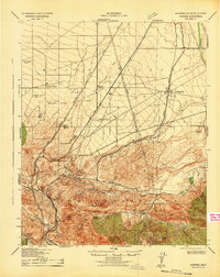
The Atchison Topeka and Santa Fe railroad threads through this 1942 survey, marking the transition from the high desert of the Mohave Desert into the mountainous terrain of the San Bernardino National Forest. This era shows a landscape of established ranching and vital infrastructure, where the Boulder Dam Power Lines and California Nevada Power Lines intersect the arid plains near Hesperia. The southern portion of the map is dominated by the steep relief of the San Bernardino Mountains, centered around Cajon Pass and the Cajon Summit Lookout.
Find a feature on this map
44 named features on this map. Tap any name to fly to it.
Don’t see what you’re looking for? This feature index may not catch every label — zoom into the map to look around manually.
Map Details
Editions of this 1942 Hesperia Map
This is the sole edition of this map. No revisions or reprints were ever made.
Other maps of this area

1896 · San Bernardino
USGS Topo · 1:62,500

1897 · Cucamonga
USGS Topo · 1:62,500

1898 · San Bernardino
USGS Topo · 1:62,500

1899 · Redlands
USGS Topo · 1:62,500

1900 · Cucamonga
USGS Topo · 1:62,500

1901 · Southern California Sheet No. 1
USGS Topo · 1:250,000

1901 · San Bernardino
USGS Topo · 1:62,500

1901 · Redlands
USGS Topo · 1:62,500

1902 · Deep Creek
USGS Topo · 1:62,500

1902 · Hesperia
USGS Topo · 1:62,500