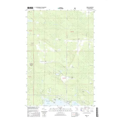
2017 Map of Hessel
USGS Topo · Published 2017About this map
Hessel serves as the focal point for this survey along the northern shores of Lake Huron, where the Les Cheneaux Islands region meets the mainland. The landscape is defined by the transition from the protected waters of Hessel Bay and Mackinac Bay to the inland timberlands of the Hiawatha National Forest. Local history is deeply etched into the terrain through a high concentration of cemeteries, including Italian Hill Cem, Rockview Cem, Fenlons Cem, and the prominent Father Marquette's Cem near the waterfront. Inland, the topography rises toward Peek-A-Boo Hill, while smaller water bodies like Bay City Lake and Pollock Lake dot the forested interior. The map illustrates a coastal economy centered on the water, with Burnham Island and Avery Point marking the jagged shoreline that has long drawn seasonal visitors and maritime traffic to this part of the Upper Peninsula.
Find a feature on this map
56 named features on this map. Tap any name to fly to it.
Don’t see what you’re looking for? This feature index may not catch every label — zoom into the map to look around manually.
Map Details
Editions of this 2017 Hessel Map
This is the sole edition of this map. No revisions or reprints were ever made.
Other maps of this area

1931 · Pickford SE
USGS Topo · 1:31,680

1932 · St Ignace NE
USGS Topo · 1:31,680

1953 · Pickford NW
USGS Topo · 1:24,000
1953 · Rudyard
USGS Topo · 1:24,000
1953 · Pickford
USGS Topo · 1:24,000

1954 · Sault Sainte Marie
USGS Topo · 1:250,000

1955 · Cheboygan
USGS Topo · 1:250,000

1956 · Sault Sainte Marie
USGS Topo · 1:250,000

1957 · Sault Sainte Marie
USGS Topo · 1:250,000

1958 · Cheboygan
USGS Topo · 1:250,000