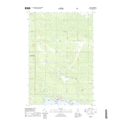
2019 Map of Hessel
USGS Topo · Published 2019About this map
Hessel anchors the northern shore of Lake Huron on this 2019 survey, where the rugged Upper Peninsula landscape meets the Les Cheneaux region. The map documents several small, specialized burial grounds including Italian Hill Cem, Fenlons Cem, and Father Marquette's Cem, which offer significant value for genealogical research in Mackinac County. The coastal geography is defined by prominent points like Osogwin Point and Mortsen Point, framing the waters of Hessel Bay and Mackinac Bay. Inland, the terrain rises toward Italian Hill and Peek-A- Boo Hill, largely encompassed by the eastern stretches of the Hiawatha National Forest. A network of rural roads such as Rockview Rd and Nye Rd connects these wooded uplands to the waterfront, while the Albert J Lindberg Airport serves as a modern aviation landmark amidst the traditional forest and lake landscape.
Find a feature on this map
52 named features on this map. Tap any name to fly to it.
Don’t see what you’re looking for? This feature index may not catch every label — zoom into the map to look around manually.
Map Details
Editions of this 2019 Hessel Map
This is the sole edition of this map. No revisions or reprints were ever made.
Other maps of this area

1931 · Pickford SE
USGS Topo · 1:31,680

1932 · St Ignace NE
USGS Topo · 1:31,680

1953 · Pickford NW
USGS Topo · 1:24,000
1953 · Rudyard
USGS Topo · 1:24,000
1953 · Pickford
USGS Topo · 1:24,000

1954 · Sault Sainte Marie
USGS Topo · 1:250,000

1955 · Cheboygan
USGS Topo · 1:250,000

1956 · Sault Sainte Marie
USGS Topo · 1:250,000

1957 · Sault Sainte Marie
USGS Topo · 1:250,000

1958 · Cheboygan
USGS Topo · 1:250,000