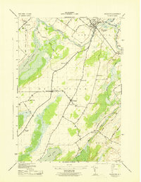
1943 Map of Heuvelton
USGS Topo · Published 1943About this map
The Oswegatchie River and the northern tip of Black Lake anchor this 1943 survey of St. Lawrence County, showing a landscape defined by small agrarian communities and a dense network of district schools. The village of Heuvelton serves as the central hub, situated where the New York Central railroad crosses the river. The map captures a high degree of rural detail, including the numbered school system ranging from School No 15 near Lost Village to the Fish Creek School further south. Genealogists can find several family-named landmarks and burial grounds, such as Purmort Cem and Mt Lona Cem, alongside small crossroads like Kokomo Corners and the settlement of De Peyster. The presence of the Gaging Station and various river-bottom wetlands illustrates the importance of the local watershed to the surrounding towns of De Peyster and De Kalb.
Find a feature on this map
41 named features on this map. Tap any name to fly to it.
Don’t see what you’re looking for? This feature index may not catch every label — zoom into the map to look around manually.
Map Details
Editions of this 1943 Heuvelton Map
This is the sole edition of this map. No revisions or reprints were ever made.
Other maps of this area

1904 · Ogdensburg
USGS Topo · 1:62,500

1905 · Ogdensburg
USGS Topo · 1:62,500

1906 · Brier Hill
USGS Topo · 1:62,500

1912 · Hammond
USGS Topo · 1:62,500

1915 · Gouverneur
USGS Topo · 1:62,500

1937 · Gouverneur
USGS Topo · 1:62,500

1943 · Ogdensburg East
USGS Topo · 1:31,680

1943 · Rensselaer Falls
USGS Topo · 1:31,680

1943 · Lisbon
USGS Topo · 1:31,680

1943 · Edwardsville
USGS Topo · 1:31,680