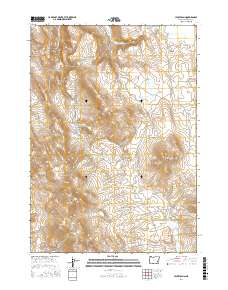
2017 Map of Hickey Basin
USGS Topo · Published 2017About this map
Hickey Basin defines the central topography of this Malheur County landscape, where the seasonal management of water is evident through a sophisticated network of small-scale impoundments. The terrain is characterized by high-desert features such as the Swamp Creek Buttes and Dry Buttes, with water drainage centered around Hickey Cr and Granite Cr. The prevalence of named catchments like Bar Heart Reservoir, Andy Wilson Reservoir, and New Visher Reservoir indicates the critical importance of water rights and livestock management in this arid stretch of Oregon.
Find a feature on this map
28 named features on this map. Tap any name to fly to it.
Don’t see what you’re looking for? This feature index may not catch every label — zoom into the map to look around manually.
Map Details
Editions of this 2017 Hickey Basin Map
This is the sole edition of this map. No revisions or reprints were ever made.
Other maps of this area

1955 · Burns
USGS Topo · 1:250,000

1955 · Boise
USGS Topo · 1:250,000

1958 · Burns
USGS Topo · 1:250,000

1958 · Boise
USGS Topo · 1:250,000

1959 · Burns
USGS Topo · 1:250,000

1962 · Boise
USGS Topo · 1:250,000

1972 · Shumway Reservoir
USGS Topo · 1:24,000

1972 · Crowley
USGS Topo · 1:24,000
1972 · Star Creek Reservoir
USGS Topo · 1:24,000
1972 · Mc Ewen Butte
USGS Topo · 1:24,000