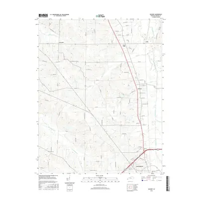
2016 Map of Hickory
USGS Topo · Published 2016About this map
Pottsville and Hickory anchor a landscape defined by the convergence of drainage systems and expanding infrastructure north of Mayfield. The geography is intricately carved by tributaries like W Fork Mayfield Cr and Wilson Creek, which dictate the placement of smaller communities such as West Viola and Viola. A notable institutional presence is found at Mid-Continent Univ, situated just north of the city limits. The transportation network shows a clear evolution, with established routes like the Purchase Pkwy cutting across the more traditional grid of local farm-to-market roads. This 2016 survey documents a region balancing its rural agricultural roots with the suburban growth of its county seat. Genealogists will find several burial sites well-preserved in this modern layout, including Old Union Cem, Wright Cem, and Maplewood Cem on the northern edge of the Mayfield urban area.
Find a feature on this map
90 named features on this map. Tap any name to fly to it.
Don’t see what you’re looking for? This feature index may not catch every label — zoom into the map to look around manually.
Map Details
Editions of this 2016 Hickory Map
This is the sole edition of this map. No revisions or reprints were ever made.
Other maps of this area

1936 · Farmington
USGS Topo · 1:24,000

1936 · Melber
USGS Topo · 1:24,000

1936 · Symsonia
USGS Topo · 1:24,000

1936 · Westplains
USGS Topo · 1:24,000

1951 · Farmington
USGS Topo · 1:24,000

1951 · Melber
USGS Topo · 1:24,000

1951 · Hickory
USGS Topo · 1:24,000
1951 · Symsonia
USGS Topo · 1:24,000
1951 · Westplains
USGS Topo · 1:24,000

1951 · Hickory
USGS Topo · 1:62,500