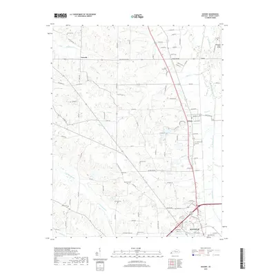
2019 Map of Hickory
USGS Topo · Published 2019About this map
Pottsville and Hickory serve as the primary anchors of this Graves County landscape, situated along a network of country roads north of Mayfield. The terrain is defined by the Tennessee Valley Divide and several drainage systems, including Wilson Creek and Mayfield Creek. This 2019 survey documents a rural environment where legacy family plots and community resting places are numerous, featuring sites like the Moore Family Cem, New Zion Cem, and three distinct Dowdy locations: Dowdy Cem, New Dowdy Cem, and Old Dowdy Cem. Economic activity is represented by the Pioneer Industrial Dr near Hickory, while the surrounding area maintains its traditional character through named routes such as Voila Pottsville Rd and Old Plant Rd, illustrating the persistence of local place names in western Kentucky.
Find a feature on this map
75 named features on this map. Tap any name to fly to it.
Don’t see what you’re looking for? This feature index may not catch every label — zoom into the map to look around manually.
Map Details
Editions of this 2019 Hickory Map
This is the sole edition of this map. No revisions or reprints were ever made.
Other maps of this area

1936 · Farmington
USGS Topo · 1:24,000

1936 · Melber
USGS Topo · 1:24,000

1936 · Symsonia
USGS Topo · 1:24,000

1936 · Westplains
USGS Topo · 1:24,000

1951 · Farmington
USGS Topo · 1:24,000

1951 · Melber
USGS Topo · 1:24,000

1951 · Hickory
USGS Topo · 1:24,000
1951 · Symsonia
USGS Topo · 1:24,000
1951 · Westplains
USGS Topo · 1:24,000

1951 · Hickory
USGS Topo · 1:62,500