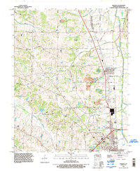
1994 Map of Hickory
USGS Topo · Published 1996About this map
Pottsville and Hickory anchor this western Kentucky landscape, where the agricultural tradition of Graves County met late 20th-century transportation expansion. The map detail highlights a network of family-named roads like Jerry Doyle Road and Cecil Carter Road, tracing the lineage of local landownership alongside established spiritual centers such as Hope Church. The terrain is defined by the drainage of Mayfield Creek and its many tributaries, including Goose Creek and Gilbert Creek, which carve through the clay-rich soils of the region.
Find a feature on this map
59 named features on this map. Tap any name to fly to it.
Don’t see what you’re looking for? This feature index may not catch every label — zoom into the map to look around manually.
Map Details
Editions of this 1994 Hickory Map
This is the sole edition of this map. No revisions or reprints were ever made.
Other maps of this area

1936 · Farmington
USGS Topo · 1:24,000

1936 · Melber
USGS Topo · 1:24,000

1936 · Symsonia
USGS Topo · 1:24,000

1936 · Westplains
USGS Topo · 1:24,000

1951 · Farmington
USGS Topo · 1:24,000

1951 · Melber
USGS Topo · 1:24,000

1951 · Hickory
USGS Topo · 1:24,000
1951 · Symsonia
USGS Topo · 1:24,000
1951 · Westplains
USGS Topo · 1:24,000

1951 · Hickory
USGS Topo · 1:62,500