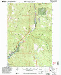
2000 Map of Hidden Lakes
USGS Topo · Published 2005About this map
Gallatin Canyon serves as the central artery of this Montana landscape, where the Gallatin River carves through the rugged terrain of the Gallatin National Forest. At the turn of the 21st century, the map illustrates the delicate balance between public lands and private holdings, notably around the Karat Ranch and the designated Metcalf (Spanish Peaks Unit) Wilderness. Access to the high country is marked by landmarks such as Highs Bridge and Jack Smith Bridge, providing entry points for those traversing toward the Spanish Peaks or the secluded Hidden Lakes in the southeast. The inclusion of the Gallatin Wildlife Management Area and the Moose Creek Flat Recreation Site highlights the region's managed intersection of conservation and outdoor recreation during this era.
Find a feature on this map
30 named features on this map. Tap any name to fly to it.
Don’t see what you’re looking for? This feature index may not catch every label — zoom into the map to look around manually.
Map Details
Editions of this 2000 Hidden Lakes Map
This is the sole edition of this map. No revisions or reprints were ever made.
Other maps of this area

1888 · Three Forks
USGS Topo · 1:250,000

1894 · Three Forks
USGS Topo · 1:250,000

1895 · Three Forks
USGS Topo · 1:250,000

1947 · Bozeman
USGS Topo · 1:250,000

1948 · Bozeman
USGS Topo · 1:250,000

1950 · Spanish Peaks
USGS Topo · 1:62,500

1950 · Sphinx Mountain
USGS Topo · 1:62,500

1955 · Bozeman
USGS Topo · 1:250,000

1955 · Garnet Mountain
USGS Topo · 1:62,500

1955 · Crown Butte
USGS Topo · 1:62,500