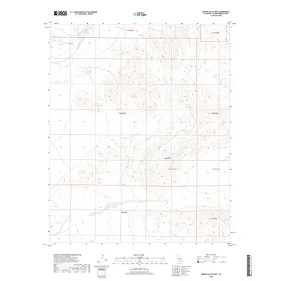
2018 Map of Hidden Valley West
USGS Topo · Published 2018About this map
Cady Mountains dominate this arid landscape within the Mojave Desert as it appeared in 2018. The map centers on the high-elevation drainage patterns of the region, where the prominent Wilhelm Wash and its various tributaries cut through the complex terrain of the northern Cady range. In this dry environment, the appearance of the Ninemile Waterhole in the northwest corner suggests a critical historic point for travelers or livestock. The eastern portion of the sheet opens into the broad expanse of Hidden Valley, showcasing the stark transition between steep mountain slopes and the relatively flat basin floor typical of the California desert interior.
Find a feature on this map
11 named features on this map. Tap any name to fly to it.
Don’t see what you’re looking for? This feature index may not catch every label — zoom into the map to look around manually.
Map Details
Editions of this 2018 Hidden Valley West Map
This is the sole edition of this map. No revisions or reprints were ever made.
Other maps of this area

1933 · Avawatz Mountains
USGS Topo · 1:250,000

1947 · Trona
USGS Topo · 1:250,000

1948 · Trona
USGS Topo · 1:250,000
1948 · Alvord Mountain
USGS Topo · 1:62,500
1948 · Cave Mountain
USGS Topo · 1:62,500
1951 · Cave Mountain
USGS Topo · 1:62,500
1951 · Alvord Mountain
USGS Topo · 1:62,500
1953 · San Bernardino
USGS Topo · 1:250,000

1953 · Trona
USGS Topo · 1:250,000
1955 · Newberry
USGS Topo · 1:62,500