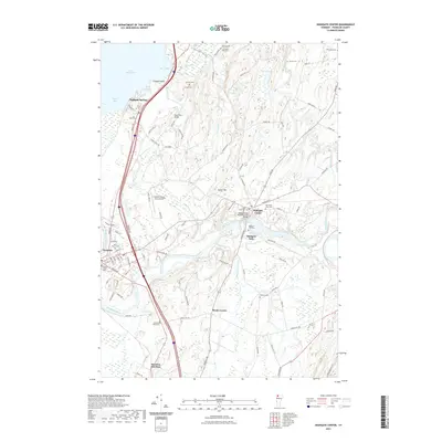
2021 Map of Highgate Center
USGS Topo · Published 2021About this map
The Missisquoi River winds through the heart of northern Vermont, anchoring the historic communities of Highgate Center and Highgate Falls. This 2021 survey details the dense settlement of Swanton and its surrounding hamlets, where the landscape transitions from the shores of Lake Champlain at Rock River Bay and Goose Bay into the interior wetlands and brooks. A notable concentration of genealogical sites is evident across the terrain, including Saint Marys Cem, Saint Louis Cem, and the Webster Cem. Transportation and infrastructure are central themes, featuring the Franklin County State Airport and the architecturally significant Highgate Falls Parabolic Truss Bridge. From the northern border at Highgate Springs down to Swanton Junction, the map illustrates a rural landscape defined by family-named roads like Partlow Rd and Tarte Rd, and landforms such as Limekiln Point and Carter Hill.
Find a feature on this map
97 named features on this map. Tap any name to fly to it.
Don’t see what you’re looking for? This feature index may not catch every label — zoom into the map to look around manually.
Map Details
Editions of this 2021 Highgate Center Map
This is the sole edition of this map. No revisions or reprints were ever made.
Other maps of this area

1914 · St. Albans
USGS Topo · 1:48,000

1916 · St. Albans
USGS Topo · 1:62,500

1920 · Franklin Pond
USGS Topo · 1:62,500

1922 · Enosburg Falls
USGS Topo · 1:48,000

1924 · Enosburg Falls
USGS Topo · 1:62,500

1943 · St. Albans
USGS Topo · 1:62,500

1944 · Enosburg Falls
USGS Topo · 1:62,500

1950 · Lake Champlain
USGS Topo · 1:250,000
1953 · Enosburg Falls
USGS Topo · 1:62,500

1958 · Lake Champlain
USGS Topo · 1:250,000