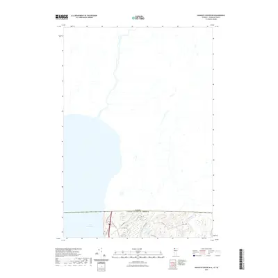
2021 Map of Highgate Center OE N
USGS Topo · Published 2021About this map
Lake Champlain dominates the southwestern corner of this survey, defining the international boundary where the northern edge of the United States meets Canada. The landscape is characterized by the winding path of the Rock River, which meanders through the eastern portion of the terrain before crossing north. For those researching local history or genealogy, several small family burial sites are preserved here, including Deal Cem located near Rheaume Rd and Brewer Cem situated further east. The road network, featuring routes such as Welcome Ctr Rd and Country Club Rd, suggests a mix of transit and local access near the border. Significant hydrological features like Proper Pond and the surrounding wetlands illustrate the low-lying drainage patterns typical of this borderland region.
Find a feature on this map
13 named features on this map. Tap any name to fly to it.
Don’t see what you’re looking for? This feature index may not catch every label — zoom into the map to look around manually.
Map Details
Editions of this 2021 Highgate Center OE N Map
This is the sole edition of this map. No revisions or reprints were ever made.
Other maps of this area

1914 · St. Albans
USGS Topo · 1:48,000

1916 · St. Albans
USGS Topo · 1:62,500

1920 · Franklin Pond
USGS Topo · 1:62,500

1922 · Enosburg Falls
USGS Topo · 1:48,000

1924 · Enosburg Falls
USGS Topo · 1:62,500

1943 · St. Albans
USGS Topo · 1:62,500

1944 · Enosburg Falls
USGS Topo · 1:62,500

1950 · Lake Champlain
USGS Topo · 1:250,000
1953 · Enosburg Falls
USGS Topo · 1:62,500

1958 · Lake Champlain
USGS Topo · 1:250,000