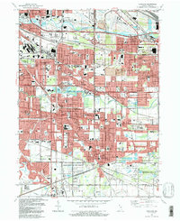
1991 Map of Highland
USGS Topo · Published 1992About this map
The Grand Calumet River and Little Calumet River define the industrial and residential corridors of Northwest Indiana in this detailed survey. While the northern reaches show the infrastructure of East Chicago and Gary, including a slag dump and the Indiana East-West Toll Road, the southern landscape transitions into the preserved wetlands of the Indiana Dunes National Lakeshore. The map documents a densely developed suburban network where Highland, Griffith, and Munster coalesce around historical rail grades and drainage projects like the Cady Marsh Ditch. Local history is anchored by numerous institutions, from the Purdue University Calumet Center to a high concentration of parish schools and cemeteries such as St Johns Cem and Ridge Lawn Cemeteries, reflecting the deep-rooted community character of Lake County.
Find a feature on this map
102 named features on this map. Tap any name to fly to it.
Don’t see what you’re looking for? This feature index may not catch every label — zoom into the map to look around manually.
Map Details
Editions of this 1991 Highland Map
This is the sole edition of this map. No revisions or reprints were ever made.
Other maps of this area

1892 · Calumet
USGS Topo · 1:62,500

1893 · Calumet
USGS Topo · 1:62,500

1900 · Toleston
USGS Topo · 1:62,500

1900 · Calumet
USGS Topo · 1:62,500

1901 · Calumet
USGS Topo · 1:62,500

1929 · Calumet Lake
USGS Topo · 1:24,000

1929 · Calumet City
USGS Topo · 1:24,000

1929 · Dyer
USGS Topo · 1:24,000

1930 · Dyer
USGS Topo · 1:24,000

1949 · Crete
USGS Topo · 1:62,500