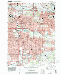
1998 Map of Highland
USGS Topo · Published 2001About this map
The Indiana Dunes National Lakeshore offers a significant natural contrast to the dense residential and industrial grid of Northwest Indiana in the late 1990s. This survey documents the closely integrated boundaries of Highland, Hammond, and Griffith, where an extensive network of drainage features like the Cady Marsh Ditch and the Grand Calumet River define the low-lying terrain. The map captures a landscape shaped by transportation and industry, from the Gary Municipal Airport and the Slag Dump in the northeast to the complex interchanges of the Tri-State Highway. Local infrastructure is highly detailed, featuring numerous parochial schools such as Our Lady of Grace Sch and St Catherine of Siena Sch, alongside local landmarks like the Woodmar Country Club. The transition from industrial rail corridors to community parks like Wicker Park and Brantwood Park illustrates the suburban evolution of Lake County during this era.
Find a feature on this map
107 named features on this map. Tap any name to fly to it.
Don’t see what you’re looking for? This feature index may not catch every label — zoom into the map to look around manually.
Map Details
Editions of this 1998 Highland Map
This is the sole edition of this map. No revisions or reprints were ever made.
Other maps of this area

1892 · Calumet
USGS Topo · 1:62,500

1893 · Calumet
USGS Topo · 1:62,500

1900 · Toleston
USGS Topo · 1:62,500

1900 · Calumet
USGS Topo · 1:62,500

1901 · Calumet
USGS Topo · 1:62,500

1929 · Calumet Lake
USGS Topo · 1:24,000

1929 · Calumet City
USGS Topo · 1:24,000

1929 · Dyer
USGS Topo · 1:24,000

1930 · Dyer
USGS Topo · 1:24,000

1949 · Crete
USGS Topo · 1:62,500