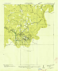
1935 Map of Highlands
USGS Topo · Published 1935About this map
Highlands occupies a prominent plateau within the Nantahala National Forest in this 1935 survey. The town is depicted during its early growth as a mountain retreat, centered near the Highlands Country Club and Highlands Lake. The map illustrates the region's burgeoning utility infrastructure, including the Municipal Power Dam and the extensive Nantahala Power and Light Company Transmission Line No 28 winding across the Cowee Mountains.
Find a feature on this map
39 named features on this map. Tap any name to fly to it.
Don’t see what you’re looking for? This feature index may not catch every label — zoom into the map to look around manually.
Map Details
Editions of this 1935 Highlands Map
This is the sole edition of this map. No revisions or reprints were ever made.
Other maps of this area

1886 · Walhalla
USGS Topo · 1:125,000

1891 · Cowee
USGS Topo · 1:125,000

1892 · Walhalla
USGS Topo · 1:125,000

1896 · Walhalla
USGS Topo · 1:125,000

1897 · Cowee
USGS Topo · 1:125,000

1907 · Cowee
USGS Topo · 1:125,000

1935 · Cashiers
USGS Topo · 1:24,000

1935 · Scaly
USGS Topo · 1:24,000

1935 · Rabun Bald
USGS Topo · 1:24,000

1935 · Glenville
USGS Topo · 1:24,000