
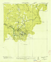
1935 Map of Rabun Bald
USGS Topo · Published 1935About this map
Rabun Bald Rabun No 2 serves as the focal point of this 1935 survey, where a prominent Fire Tower overlooks the meeting of Georgia and North Carolina. The landscape is defined by the high elevations of the Nantahala National Forest and the Blue Ridge, with water rushing through Estatoah Falls and the Little Tenn River. The map highlights a network of mountain gaps and knobs that dictated early travel and land use, such as Blue Ridge Gap and Aleek Gap.
Find a feature on this map
53 named features on this map. Tap any name to fly to it.
Don’t see what you’re looking for? This feature index may not catch every label — zoom into the map to look around manually.
Map Details
Editions of this 1935 Rabun Bald Map
This is the sole edition of this map. No revisions or reprints were ever made.
Other maps of this area

1886 · Walhalla
USGS Topo · 1:125,000

1891 · Cowee
USGS Topo · 1:125,000

1892 · Walhalla
USGS Topo · 1:125,000

1896 · Walhalla
USGS Topo · 1:125,000

1897 · Cowee
USGS Topo · 1:125,000

1907 · Cowee
USGS Topo · 1:125,000

1935 · Prentiss
USGS Topo · 1:24,000

1935 · Dillard
USGS Topo · 1:24,000

1935 · Scaly
USGS Topo · 1:24,000
1935 · Highlands
USGS Topo · 1:24,000