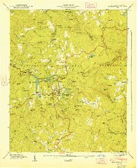
1947 Map of Highlands
USGS Topo · Published 1947About this map
Highlands serves as the focal point of this 1946 field study, situated atop a high plateau within the Nantahala National Forest. The town's mid-century character is defined by its recreational and residential infrastructure, including the Highlands Country Club and the clustered waters of Mirror Lake and Harris Lake. To the west, the Cullasaja River carves through the terrain, passing landmark cataracts such as Bridal Veil Falls and Dry Falls near the Vanhook Wayside Park. The survey captures a landscape of steep peaks like Satulah Mtn and Shortoff Mtn transitioned by gaps and knobs, illustrating the topographic isolation that shaped this mountain community. Genealogists and local historians will find significant detail in the rural outskirts, where the Horse Cove Cem and Highlands Cem are documented alongside country institutions like Shortoff Ch and Clear Creek Sch near the southern boundary with Georgia.
Find a feature on this map
131 named features on this map. Tap any name to fly to it.
Don’t see what you’re looking for? This feature index may not catch every label — zoom into the map to look around manually.
Map Details
Editions of this 1947 Highlands Map
2 editions found
Other maps of this area

1886 · Walhalla
USGS Topo · 1:125,000

1891 · Cowee
USGS Topo · 1:125,000

1892 · Walhalla
USGS Topo · 1:125,000

1896 · Walhalla
USGS Topo · 1:125,000

1897 · Cowee
USGS Topo · 1:125,000

1907 · Cowee
USGS Topo · 1:125,000

1935 · Cashiers
USGS Topo · 1:24,000

1935 · Scaly
USGS Topo · 1:24,000

1935 · Rabun Bald
USGS Topo · 1:24,000

1935 · Glenville
USGS Topo · 1:24,000