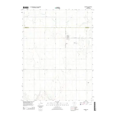
2014 Map of Hildreth
USGS Topo · Published 2014About this map
Hildreth sits at the intersection of local routes and memory in the heart of the Nebraska plains, straddling the line between Kearney and Franklin counties. This landscape is defined by the rigid geometry of rural roads, including Ne-4 and the Harold Jurgens Expy, which cut across the rolling terrain shaped by the W Br Thompson Cr and Center Cr. The map captures the community's local infrastructure, such as the town Po and the outlying Bunger Field. For those tracing local roots, the presence of both the Hildreth Cem and Saint Peters Cem provides specific locations for genealogical research. The survey illustrates how the grid system dominates the agricultural landscape, with named routes like X Rd and Y Rd providing the essential framework for regional movement.
Find a feature on this map
22 named features on this map. Tap any name to fly to it.
Don’t see what you’re looking for? This feature index may not catch every label — zoom into the map to look around manually.
Map Details
Editions of this 2014 Hildreth Map
This is the sole edition of this map. No revisions or reprints were ever made.
Other maps of this area

1896 · Holdrege
USGS Topo · 1:125,000

1897 · Red Cloud
USGS Topo · 1:125,000

1955 · Grand Island
USGS Topo · 1:250,000

1957 · Grand Island
USGS Topo · 1:250,000

1958 · Grand Island
USGS Topo · 1:250,000

1969 · Upland
USGS Topo · 1:24,000
1969 · Minden South
USGS Topo · 1:24,000

1970 · Axtell West
USGS Topo · 1:24,000
1970 · Axtell East
USGS Topo · 1:24,000

1970 · Wilcox
USGS Topo · 1:24,000