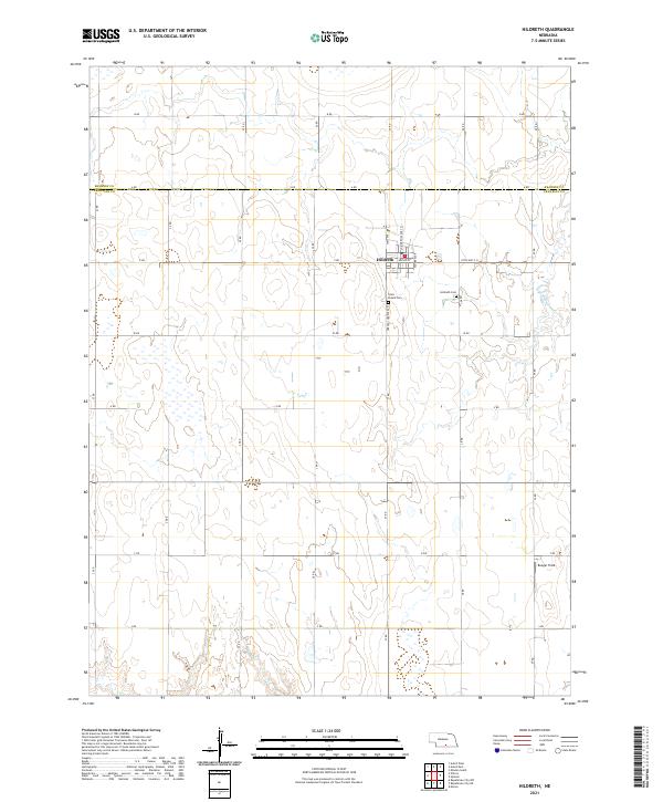
2021 Map of Hildreth
USGS Topo · Published 2021About this map
Hildreth serves as the primary hub of this agricultural landscape along the Kearney County and Franklin County line. The village is neatly gridded, centered around the intersection of State Hwy S-31, Commercial Ave St, and West Ave. A distinct network of section-line roads, including B Rd and 23 Rd, organizes the surrounding prairie, illustrating the enduring influence of the Public Land Survey System on Nebraska's rural development. To the south and east of the town center, Hildreth Cem and Saint Peters Cem provide important geographic anchors for genealogists and local historians. The eastern edge of the quadrangle is defined by the wandering path of W Br Thompson Cr, while the small landing strip at Bunger Field in the southeast corner points to the area's modern utility.
Find a feature on this map
35 named features on this map. Tap any name to fly to it.
Don’t see what you’re looking for? This feature index may not catch every label — zoom into the map to look around manually.
Map Details
Editions of this 2021 Hildreth Map
This is the sole edition of this map. No revisions or reprints were ever made.
Other maps of this area

1896 · Holdrege
USGS Topo · 1:125,000

1897 · Red Cloud
USGS Topo · 1:125,000

1955 · Grand Island
USGS Topo · 1:250,000

1957 · Grand Island
USGS Topo · 1:250,000

1958 · Grand Island
USGS Topo · 1:250,000

1969 · Upland
USGS Topo · 1:24,000
1969 · Minden South
USGS Topo · 1:24,000

1970 · Axtell West
USGS Topo · 1:24,000
1970 · Axtell East
USGS Topo · 1:24,000

1970 · Wilcox
USGS Topo · 1:24,000