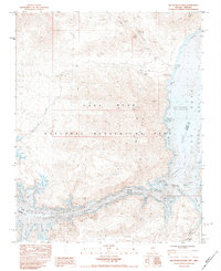
1983 Map of Hiller Mountains
USGS Topo · Published 1984About this map
The Hiller Mountains rise sharply above the southern reaches of Lake Mead, defining a rugged desert landscape along the border of Nevada and Arizona in the early 1980s. This survey captures the intricate shoreline of the Lake Mead National Recreation Area as the water reaches into Virgin Canyon and various inlets like Gold Cross Bay and Reef Bay. The terrain is marked by remnants of early 20th-century extraction, with several named operations including the Jumbo Mine, Eureka Mine, and the Joker Mine, the latter featuring its own Landing Strip. Away from the water, the topography is punctuated by Gregg Peak and Powell Mountain, while numerous prospects and 4WD tracks suggest a history of prospecting and remote exploration in this transition zone between the Colorado River corridor and the high desert peaks.
Find a feature on this map
44 named features on this map. Tap any name to fly to it.
Don’t see what you’re looking for? This feature index may not catch every label — zoom into the map to look around manually.
Map Details
Editions of this 1983 Hiller Mountains Map
This is the sole edition of this map. No revisions or reprints were ever made.
Other maps of this area

1886 · Camp Mohave
USGS Topo · 1:250,000

1886 · Saint Thomas
USGS Topo · 1:250,000

1892 · Camp Mohave
USGS Topo · 1:250,000

1893 · Saint Thomas
USGS Topo · 1:250,000

1926 · Bonelli
USGS Topo · 1:96,000

1942 · Camp Mohave
USGS Topo · 1:250,000

1947 · Kingman
USGS Topo · 1:250,000

1948 · Kingman
USGS Topo · 1:250,000

1953 · Iceberg Canyon
USGS Topo · 1:62,500

1953 · Virgin Basin
USGS Topo · 1:62,500