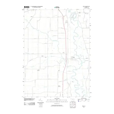
2010 Map of Hills
USGS Topo · Published 2010About this map
The Iowa River meanders through this agricultural corridor south of Iowa City, anchoring a landscape shaped by early Johnson County settlements and academic expansion. The town of Hills serves as a central hub, surrounded by smaller locales like Bon Accord, Morfordsville, and the curiously named Seventy Eight. Local history is deeply etched into the land through a high density of family and denominational burial grounds, including the Welsh Cemetery, Saint Stanislaus Cemetery, and Sandtown Cemetery. A notable scientific landmark, the University of Iowa Observatory, sits west of the river along Observatory Ave SW. The drainage network, featuring Old Mans Creek and Dirty Face Creek, illustrates the complex hydrology that influenced the placement of these early crossroads communities and farmsteads.
Find a feature on this map
55 named features on this map. Tap any name to fly to it.
Don’t see what you’re looking for? This feature index may not catch every label — zoom into the map to look around manually.
Map Details
Editions of this 2010 Hills Map
This is the sole edition of this map. No revisions or reprints were ever made.
Other maps of this area

1891 · Iowa City
USGS Topo · 1:62,500

1894 · West Liberty
USGS Topo · 1:62,500

1901 · Stanwood
USGS Topo · 1:125,000

1903 · Fairfax
USGS Topo · 1:125,000

1938 · Iowa City
USGS Topo · 1:62,500

1958 · Davenport
USGS Topo · 1:250,000

1961 · Davenport
USGS Topo · 1:250,000

1962 · Davenport
USGS Topo · 1:250,000

1965 · Williamstown
USGS Topo · 1:24,000
1965 · Tiffin
USGS Topo · 1:24,000